
“I felt my lungs inflate with the onrush of scenery – air, mountains, trees, people. I thought: This is what it is to be happy”
Sylvia Plath
I have distanced myself from most civilization for the better part of the summer. My contact with other humans, not counting my family and friends, have been nothing more than brief encounters at the grocery store. Everyone has to eat, right? With the beginning of August comes the realization that by the end of the month my life will be becoming increasingly busy as it always does that time of year. So what better way to spend the first day of August than an all day 8 mile day hike that includes a short section of The Long Trail. Someday I hope to hike the entire Long Trail, but that will have to wait.
My friend and I began the one hour and twenty minute drive to Lowell, VT at 8 am, hoping to be on the trail before 10. Trailheads are often hard to find and this trailhead proved to be no different than most. Our directions took us to a trailhead that connects to The Long Trail. After searching through a few hiking books my friend had brought along we finally found our way to the trailhead for the Frank Post Trail. From Route 100 take The North Road approximately 5 miles, then turn left onto Tillotson Road. Overshooting our trailhead ended up being a good thing. We met a group of hikers coming off The Long Trail that needed a ride to the local General Store. We gave them and their dog a ride, then continued on to our destination.
It was nearly 11 am before we began our ascent up the Frank Post Trail. Recent logging activity has left the trail difficult to navigate in the lower region. With no blazes to follow we started up the logging road. We accidentally wandered off trail when we encountered pink and blue ribbons hanging from the trees. I believe these turned out to be property lines rather than trail indicators. In our brief jaunt through the woods we found a patch of Stinging Nettles. This was my first encounter with this plant, and I greatly hope it is also my last. We made our way back to the logging road and continued to follow it upward. We were starting to wonder if we were truly on a trail at all when we finally saw the blue blazes heading into the woods. We took the trail to the right and headed up the Frank Post Trail toward Tillotson Camp. This part of the trail is fairly easy. It is steady in places but not very steep.
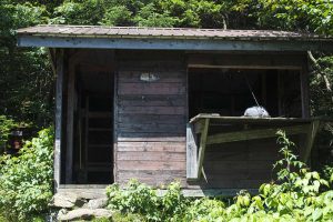
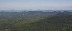
We ate lunch at Tillotson Camp. It was nice to sit at a table out of the sun while we ate. We took our time and enjoyed the view. Through the small clearing outside Tillotson Camp the Lowell Mountains Wind Project sits on the horizon. Twenty one wind turbines cover a four mile section of the ridge-line. This project has been the site of much controversy in Lowell Vermont and the neighboring towns.
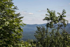
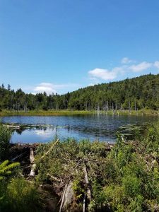
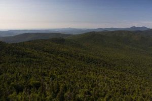
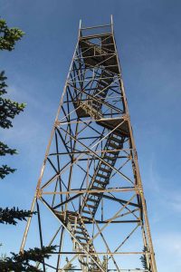
From Tillotson Camp we headed south on The Long Trail. We crossed streams, hiked hand over hand climbing rocks and roots, trekked through mud holes and encountered amazing scenery. Finally we reached the fire tower at the summit and were pleasantly surprised to run into the hikers we had given a ride that morning. We sat at the summit and chatted for quite a while. It was a long hike and a beautiful view and nobody seemed to want the day to end.
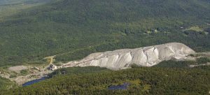
Eventually we decided it was time to descend, but first we climbed the fire tower to take in the full 360 degree breathtaking views. Jay Peak can be seen to the north. To the east at the base of Belvidere Mountain lays an old asbestos mine.
Vermont was one of the first state in the country to mine asbestos. The New England Asbestos Mining and Milling Company began operations in Vermont in 1899. Asbestos mining continued on Belvidere Mountain until 1993, making it one of the last asbestos mines in the country to close. Today piles of asbestos along with millions of tons of asbestos rock that have been processed to some degree still sit at the mining site.
It was now time to finish our hike. We completed our loop by descending via the Foresters Trail. There is some erosion in the upper regions of this trail, making it a bit tricky, but for the most part it is not too difficult.
This loop is approximately 8 miles. Tillotson Road Trailhead to Tillotson Camp via the Frank Post Trail 2 miles, Tillotson Camp to Belvidere Summit via The Long Trail south 3 miles, Belvidere Summit to Tillotson Road Trailhead via the Foresters Trail 3 miles. This is an amazing day hike. Start early and take your time to enjoy the journey.
To see more pictures from this hike please visit my facebook page. Just follow the link at the top of the website.
Recent Comments